
USA & World
UN Backs New World Map Projection That Shows Africa Closer to Its True Size
The United Nations General Assembly has backed wider use of the Equal Earth map projection, a design that shows Africa much closer to its true geographic size — correcting distortions that have persisted since the Mercator map was created in 1569.
By Dwight Simpson
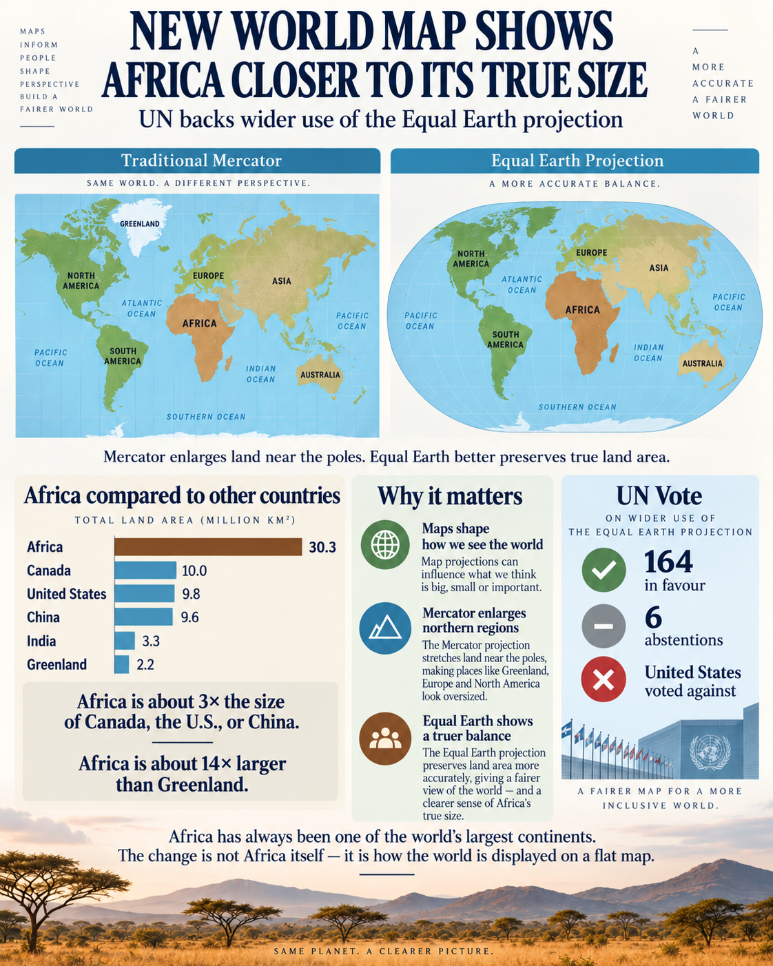
UNITED NATIONS — September 5, 2026 — A major change in how the world may be represented on maps is gaining international attention after the United Nations General Assembly backed wider use of the Equal Earth map projection, a design that shows Africa much closer to its true geographic size.
For generations, many classrooms, offices, textbooks and websites have relied on the familiar Mercator projection. While the Mercator map remains useful for navigation, it greatly stretches areas closer to the North and South Poles.
That distortion makes places such as Greenland, Canada, Russia and northern Europe appear much larger compared with regions closer to the equator.
Africa, meanwhile, has often appeared much smaller than it really is.
How Was the Map Changed?
The important thing to understand is that countries were not physically moved and Africa did not suddenly become larger.
The change comes from using a different mathematical method to flatten the round Earth onto a two-dimensional map.
Every flat world map has some distortion because it is impossible to perfectly flatten a globe without stretching, shrinking or changing some parts of it.
The Mercator projection, created in 1569, was designed primarily to help sailors navigate. Its mathematical system preserves compass directions, which made it extremely useful for marine navigation.
But there is a trade-off.
As locations get farther away from the equator, the Mercator projection increasingly enlarges them.
The Equal Earth projection uses a different mathematical formula. Instead of prioritizing navigation and direction, it is an equal-area projection, meaning countries and continents maintain their correct relative areas when compared with one another.
The Equal Earth projection was developed in 2018 by cartographers Bojan Savrič, Tom Patterson and Bernhard Jenny. Their goal was to create a map that maintained accurate relative land areas while still producing a visually familiar and attractive world map.
That mathematical transformation is why Africa looks dramatically larger compared with Greenland, Europe and northern regions on an Equal Earth map.
Africa itself has not changed.
The scale of the map has.
How Did the UN Change Come About?
The movement toward a different world map did not begin with a sudden decision at the United Nations.
African governments and organizations had increasingly argued that the widespread use of the Mercator projection created a misleading visual impression of Africa.
In 2025, the African Union publicly supported efforts to encourage maps that better represented Africa's actual size, arguing that distorted maps could influence how people perceive the continent.
Togo later became one of the leading countries pushing the issue internationally.
In April 2026, Togo announced that it intended to ask United Nations member states to support a resolution encouraging the use of maps that represent Africa and other regions more proportionately.
That effort eventually resulted in a draft resolution titled "Correct the Map: Rebalancing global cartographic representation and promoting equitable representation of the world's regions, particularly Africa."
The proposal was brought before the United Nations General Assembly on September 4, 2026.
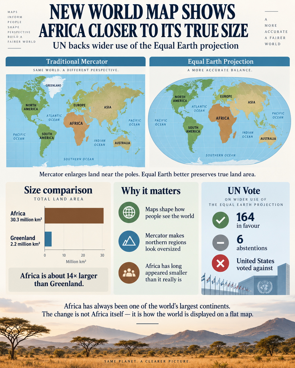
The General Assembly approved the resolution by a vote of 164 countries in favour, 1 country against — the United States — and 6 countries abstaining.
The resolution encourages governments, educational institutions, international organizations and technology companies to consider using the Equal Earth projection or other maps that more accurately represent the relative size of land masses.
The UN Did Not Ban the Old Map
Despite some headlines describing this as the United Nations "changing the world map," the decision does not mean that every Mercator map must now be destroyed or replaced.
The General Assembly resolution is not legally binding.
Countries, schools, publishers and technology companies are being encouraged to consider changing the maps they use, but individual governments and organizations will ultimately decide how quickly they make that transition.
The Mercator projection will also continue to have practical uses, particularly for navigation.
What is changing is the growing preference for equal-area maps when the goal is to compare the actual size of countries and continents.
Just How Large Is Africa?
Africa covers approximately 30.3 million square kilometres, making it the world's second-largest continent.
Compare that with several major countries and regions:
Africa: approximately 30.3 million km² Canada: approximately 10 million km² United States: approximately 9.8 million km² China: approximately 9.6 million km² India: approximately 3.3 million km² Greenland: approximately 2.2 million km²
Africa is therefore roughly three times the size of Canada, the United States or China.
It is also approximately 14 times larger than Greenland.
Yet on a traditional Mercator map, Greenland can appear surprisingly close to Africa's size.
That is one of the most striking examples of Mercator distortion.
Why the Difference Is So Dramatic
Imagine trying to peel the surface off a basketball and lay it perfectly flat on a table.
Something would have to stretch, tear or change shape.
The same problem occurs when cartographers turn the spherical Earth into a rectangular map.
Different projections solve that problem differently.
Mercator sacrifices accurate area in order to preserve direction.
Equal Earth sacrifices some other aspects of shape and distance so that relative land area remains accurate.
That means when Africa occupies a much larger portion of the Equal Earth map, the newer map is not exaggerating Africa.
It is correcting much of the exaggeration that previously occurred elsewhere.
More Than Just Geography
Supporters of the change argue that maps can influence how generations of people understand the world.
When Europe, Greenland and parts of North America appear disproportionately large while Africa appears smaller, people may subconsciously develop a distorted understanding of the relative scale of different regions.
The United Nations described the September 4 decision as an effort to address those cartographic distortions and encourage a more geographically balanced representation of the planet.
The Equal Earth projection will not make every world map identical, and no flat map can reproduce a globe perfectly.
But when the question is how much land a country or continent actually occupies, Equal Earth provides a much more accurate comparison.
Africa has always been enormous.
The world is simply beginning to see it represented closer to the size it has been all along.
Source & attribution
Reporting by CanJam News. Information in this article is based on publicly available statements and verified reporting available at publication.
Topics

